Just the Facts: Israeli Apartheid Wall

| Understanding the Israeli Apartheid Wall: Just the Facts… |
|---|
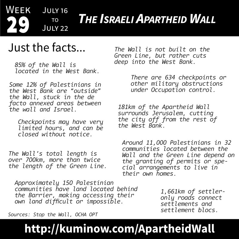
- 85% of the Wall is located in the West Bank.
- The Wall is not built on the Green Line, but rather cuts deep into the West Bank.
- Some 12% of Palestinians in the West Bank will be “outside” the Wall, stuck in the de facto annexed areas between the wall and Israel.
- The Wall’s total length will be over 700 km, more than twice the length of the 1949 Armistice (“Green”) Line.
- 1,661 km of settler-only roads connect settlements and settlement blocs and complement the Wall system.
- 634 checkpoints or other military obstructions including trenches, roadblocks, metal gates under Occupation control.
- Checkpoints may have very limited hours, and can be closed without notice.
- Around 11,000 Palestinians living in 32 communities located between the Barrier and the Green Line depend on the granting of permits or special arrangements to live in their own homes.
- Approximately 150 Palestinian communities have land located behind the Barrier, forcing residents to seek special permits or ‘prior coordination’ to access it.
- As a result of the wall and checkpoints, farmers often have to travel hours to reach their own land, located just meters from their homes.
This week’s facts come from:
- Stop the Wall’s fact sheet.
- OCHA oPt’s “The Humanitarian Impact of the Barrier”
Learning More
To learn more you can start by reading Stop the Wall’s full page on the wall and watch AJ+’s “Israel’s wall: Security or apartheid?” To go deeper, we are developing an extensive list of Additional Resources at the bottom of this week’s entry as well as a YouTube playlist on the subject.