Just the Facts: Bethlehem
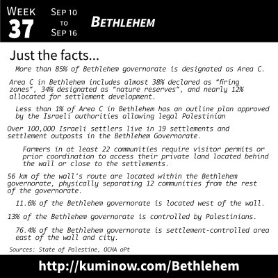

- Less than 1% of Area C in Bethlehem has an outline plan approved by the Israeli authorities allowing legal Palestinian construction.
- More than 85% of Bethlehem governorate is designated as Area C.
- Area C in Bethlehem includes almost 38% declared as “firing zones”, 34% designated as “nature reserves”, and nearly 12% allocated for settlement development.
- Over 100,000 Israeli settlers live in 19 settlements and settlement outposts in the Bethlehem Governorate.
- Farmers in at least 22 communities require visitor permits or prior coordination to access their private land located behind the wall or close to the settlements.
- 56 km of the wall’s route are located within the Bethlehem governorate, physically separating 12 communities from the rest of the governorate.
- 11.6% of the Bethlehem governorate is located west of the wall.
- 13% of the Bethlehem governorate is controlled by Palestinians.
- 76.4% of the Bethlehem governorate is settlement-controlled area east of the wall and city.
Sources
- “Bethlehem governorate: fragmentation and humanitarian concerns – January 2015” from OCHA oPt“Besieging Bethlehem: Latest Israeli Settlement Developments in Bethlehem” from the State of Palestine’s Negotiations Affairs Office
Learning More
To learn more about Bethlehem, we suggest you read “In Bethlehem, I had a vivid experience of what Israel’s occupation feels like” by Ghada Karmi for Middle East Eye and “Christmas in Bethlehem: Controlling the narrative through tourism” by Megan Giovannetti for Al Jazeera. And you can watch “Bethlehem — Hidden From View” from ARIJ Institute. To go deeper, we will be developing an extensive list of Additional Resources at the bottom of this week’s entry as well as a YouTube playlist on the subject.